If you’ve never done this before, this is actually much simpler than it sounds.
Even without realizing it, most people are familiar with geo-coordinates, because latitude and longitude are the measurements that make GPS work. More information about geodesy, the science of where, here.
There are two steps to getting location data: collecting the data, and retrieving it from your photograph, mobile device or computer.
Using a camera
Using Google Maps
Using the camera in your iPhone or iPad
Using the camera in your Android device
Collecting location data using a camera
Most cameras have geo-coordinates stored in the metadata, so you will find the latitude and longitude in your camera’s image tags, or the info menu of the image processing program that you’re using, such as Photoshop. If you don’t use an image editor, you’ll get the geo-coordinates directly from the image file.
Collecting location data with a smartphone or tablet
There are two ways you can do this: using Google maps, or using camera in your smart device. Probably the easiest way is to use Google maps.
Collecting location data using Google maps
1. On your smartphone or tablet, open the Google Maps app.
2. Bring up the My Location icon.
3. Touch and hold the area of the map next to your location. You’ll see a red pin appear.
4. Scroll down to the bottom of the window. You’ll see the latitude and the longitude.
5. You can share your location to your email or some other location in your phone, or save it to the Google map itself. (If you do this, don’t forget to give it the name of the artwork before closing the window, so you don’t get your artworks and locations mixed up. It’s been known to happen.)
Collecting location data using the camera in your phone or tablet
If you’re using the camera in a smartphone or tablet, all you have to do is make sure location services is turned on.
Turn on location services: iPhone
In the iPhone, start by going to Settings > Privacy. (Depending on the version you’re using, these screenshots might not be exactly the same.)

Turn on locations services: Android
1. On Android, go to Settings > Location (These settings might be a little different depending on the version of Android running on your phone.)
2. ‘Use GPS satellites’
3. Open the Camera app
4. Settings (gear) icon.
5. Tap the “Store Location in Pictures,” or “Geo-tag Photos” to get the green checkmark.
Step Two: Retrieve latitude and longitude
Retrieve geo-coordinates from your Mac
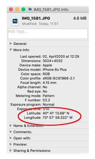
On your Mac computer, just select the image file and open the Info window (Cmd-I) and it’s right there in “More Info.”

Retrieve geo-coordinates from your PC
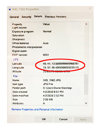
The process is similar in Windows, but everything has a different name. Right-click the image file, select Properties from the bottom of the menu, and open the Details tab.
